
SECURE
REAL-TIME
MADE FOR SMARTER OPERATIONS
XPLORERVIEW™
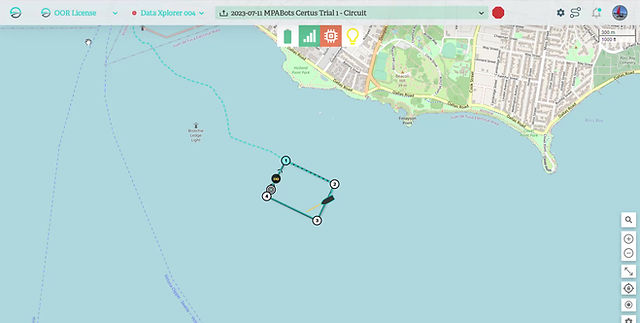
XplorerView™ is an advanced command & control system designed to optimize the performance of our solar-powered USVs. Speed, heading, and loiter radius are precisely controlled with easy-to-use tools, and multiple USVs can be operated simultaneously. Key actions can be planned and programmed for specific waypoints, including image capture, loiter, and sensor activation/deactivation.
It simplifies mission preparation with drag and drop waypoints, distance calculations, and grid survey tools. Mission parameters can also be imported, while past missions are stored in the mission library, where they can be viewed, copied, and updated for reuse.
REAL-TIME PERFORMANCE MONITORING
Real-time monitoring of system health, weather conditions, and data quality ensure optimal mission execution and data acquisition. USV operators are kept aware of key events with alerts that deliver information needed for informed decision making.
COMPREHENSIVE NAVIGATIONAL TOOLS
Navigation is simplified with a range of overlays that provide nautical navigation charts, bathymetric charts, satellite imagery, AIS, and tide tables.
PRECISION CONTROL
USV speed and direction can be tightly controlled and monitored. Missions can be pre-programmed for autonomous execution and modified as needed in real-time. The operator can also enter manual mode to control the USV directly.
POWER
MANAGEMENT
Designed to maximize the performance of solar powered USVs, XplorerView™’s intuitive platform provides power management tools to extend mission duration and optimize data collection. This includes detailed power usage and capture analytics, battery levels, solar input, and remaining mission time. Operators also can switch into low power mode and turn on or off sensors as needed.
MISSION
REPLAY
Mission telemetry and system health data, including cumulative time on water, motor running time, and battery analytics are recorded from each mission for future analysis. Collected oceanographic and environmental data is also logged and available for replay.
MARITIME SITUATIONAL AWARENESS
XplorerView™ displays USV collected maritime situational awareness data including AIS, camera feeds, radar, and depth, along with AI-driven analytics for safe navigation. Potential obstacles and collision threats are displayed along with critical data including the closest point of approach (CPA) and estimated time to arrival. Alerts can also be sent to the remote operator for timely action.